Discover Five 4WD Camping Spots in South East Queensland
South East Queensland is home to some of the most well known – and lesser known – 4WD camping locations. We share some of the best-kept secrets in the region and a few favourites.
Whether you plan to hire a 4WD or have a vehicle, these places are within easy distance to Brisbane and are ideal for a weekend getaway. Our selected South East Queensland camping spots offer 4WD tracks that range from easy to difficult. Our list includes a diversity of locations – from beach to lush green Gondwana rainforest to sub-tropical islands.
Here’s a list of the top five 4WD Camping spots in South East Queensland:
[Quick Links]
1. North Stradbroke Island
2. Mount Mee, D’Aguilar National Park
3. Cooloola Recreation Area
4. Main Range National Park
5. Benarkin National Park
Distance from Brisbane: 50 minutes drive & 45 minute ferry ride
4WD Skill level: Easy to difficult
North Stradbroke Island is literally on Brisbane’s doorstep. It’s one of the world’s biggest sand islands and famous for beautiful stretches of beaches, including spectacular surfing beaches.
Enjoy the subtropical beauty of North Stradbroke Island, with rolling turquoise, freshwater lakes and Naree Budjong Djara National Park, which covers nearly 50% of North Stradbroke Island. Visit Point Lookout, go hiking in untouched wilderness or 4WD along the beach. North Stradbroke Island has it all. You can spend a lazy day exploring North Stradbroke Island, camp for a weekend or, even, for a few weeks.
North Stradbroke Island has five main beaches that offer surfing, water sports and fishing opportunities. Main Beach is 32 kilometres long, while Cylinder Beach is a protected swimming beach and Flinders Beach offers good swimming.
With over 100 freshwater lakes and wetlands, North Stradbroke Island offers many opportunities for exploring native fauna and wildlife. Blue Lake is a tranquil and stunning turquoise blue freshwater lake. Brown Lake is a famous freshwater lake that has a distinct colour due to the leaves that line the lake floor.
Getting there:
Book the 45 minutes ferry to North Stradbroke through Stradbroke Ferries. The cost to transport a vehicle starts at $79 each way, depending on the size of your vehicle and time.
Departing from Cleveland:
Monday – Friday:
Saturday – Sunday:
North Stradbroke Island map:
Click here to view a large version of a map of North Stradbroke Island (Queensland’s Department of National Parks, Sports and Racing).
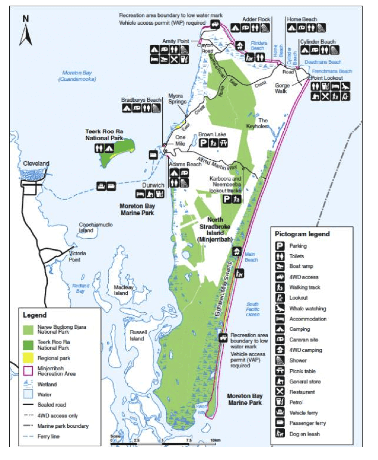
North Stradbroke Island Map – Map from Queensland’s Department of National Parks, Sports and Racing
Do I need a 4WD on North Stradbroke Island?
North Stradbroke Island is accessible by water taxi or vehicle ferry, which departs from Cleveland. You can explore the three towns of Dunwich, Amity and Point Lookout with a conventional vehicle, but most of the island requires a 4WD vehicle. You’ll also need a 4WD for driving on the beach at North Stradbroke Island. To view a map of 4WD tracks on Straddie, click here.
Do I need a permit to drive on North Stradbroke Island?
Vehicle Access Permits are required for driving on the beach and through Minjerribah Recreation Area. Buy your permit online or purchase it from one of the Minjerribah Camping offices on the Island.
4WD Tracks
4WD Beach Driving is allowed on Main Beach and Flinders Beach. The speed limit on Main Beach is 60km/h and Flinders Beach is 40km/h. Driving is not allowed an hour of each side of high tide. Click here for tide data.
To find out everything you need to know about 4WD’ing on North Stradbroke Island, read our article here. This helpful article has info about 4WD driving on the beach, a map of 4WD tracks on the island and other useful information.
Fishing
Beach fishing is popular on the island, particularly on Main Beach and Flinders Beach. Rainbow Channel, just off the shore at Amity Point has deepwater fishing, from the jetty or beach. There are two boat ramps on the island, one at Amity Point and One Mile, Dunwich.
Kayaking
Kayak in the serene brown lake, Point Lookout and the beach. Stradbroke Ferries has kayaking tours at Brown Lake, Dunwich, Amity Point, or Home Beach. Hire a kayak through Straddie Super Sports.
Swimming
Swim at the beach or at tranquil Brown Lake. Brown Lake is only 3.5km from Dunwich and the perfect spot for a swim and picnic. The brown tinge in the water comes from the tea trees surrounding the lake.
Patrolled beaches include:
Hiking
The most popular walk on North Stradbroke Island is Gorge Walk at Point Lookout, an easy 1.5km walk. You may be lucky enough to spot dolphins, turtles, fish and manta rays. During migration season, you may spot humpback whales.
Blue Lake Hiking:
The 5.2km Naree Budjong Djara National Park walk takes you to Blue Lake, surrounded by paperbarks, banksias and eucalyptus trees.
Whale Watching
Between June to November, North Stradbroke offers some of the most easterly vantage points for whale watching. The cliffs between Cylinder Beach and North Gorge, offer elevated viewing platforms – perfect for spotting a whale.
Various options for camping on North Stradbroke Island exists including glamping, beach camping and camping grounds. The Minjerribah Recreation area covers a vast region of camping spots and beaches that allow 4WD driving.
Camping grounds:
A few of the more popular camping grounds include Amity Point and Adder Rock. These family friendly camping grounds offer good facilities including communal kitchen, playground, free WiFi, washing machine, toilets, showers, power and water.
Beach camping North Stradbroke Island
Camping is only allowed in designated camping areas and a 4WD is required for access. Main Beach has 15 access tracks, 7km south of the causeway access. Flinders Beach has 12 access tracks, which start 1.5km from Adder Rock Beach.
If you decide to camp on the beach, remember a 4WD permit is necessary. Camping permits must be booked and purchased prior to arrival and a tag must be attached to your tent.
Flinders Beach camping:
The ultimate beach camping adventure awaits you at Flinders Beach. With uninterrupted views of the water and secluded, beachfront camping in the island dunes, you’ll feel like you’ve escaped to a tropical paradise. If you are planning to hire a 4WD, choose a company that allows beach driving and unlimited kilometres.
Number of sites: 200 unpowered sites available.
Facilities:
Cost: (As of May 2024) A campsite which sleeps four is from $21.80 per night. Amenities pass: $10 per campsite per night for access to Adder Rock amenities block.
What to bring:
To book your beach camping spot at Flinders Beach, North Stradbroke Island, click here.
Main Beach camping:
If long white beaches and sensational surf swells are your thing, then this is the place for you. Main Beach stretches 38km along the eastern side of North Straddie and beach camping is available. There are no facilities and access is by a 4WD vehicle along the beach. Some areas are difficult to get to as they are over high dunes. Camping is available at the southern end of Main Beach, approximately 17km south of Point Lookout. The big swell is excellent for surfing and beach fishing.
Number of sites: Fifteen designated areas.
Facilities:
Cost: (As of May 2024) A campsite which sleeps four is from $19.05 per night. Amenities pass: $10 per campsite per night for access to Adder Rock amenities block.
What to bring:
Click here to book your camping spot at Main Beach, North Stradbroke Island.
Distance from Brisbane: 57 km (if entering from Laceys Creek)
4WD Skill level: Easy if you are on the main 4WD tracks
Track Distance: 59.7 (If starting at Laceys Creek, heading to Somerset Lookout and ending at Archer camping area)
D’Aguilar National Park (formerly known as Brisbane Forest Park) offers some of the best 4WD drives in easy access of Brisbane. Covering an area of approximately 36,000 ha, it has subtropical rainforest, lush green hills, waterfalls, pools, gorges and spectacular views of Moreton Bay. Visit for a day or getaway for the weekend.
The national park is divided into two sections, South D’Aguilar and Mount Mee. South D’Aguilar National Park is behind Mount Cootha and only 13km from Brisbane’s CBD, while Mount Mee is approximately one hour’s drive.
Mount Mee driving map:
Click here to view a large version of a map of Mount Mee’s forest trail and drive map. (Queensland’s Department of National Parks, Sports and Racing).
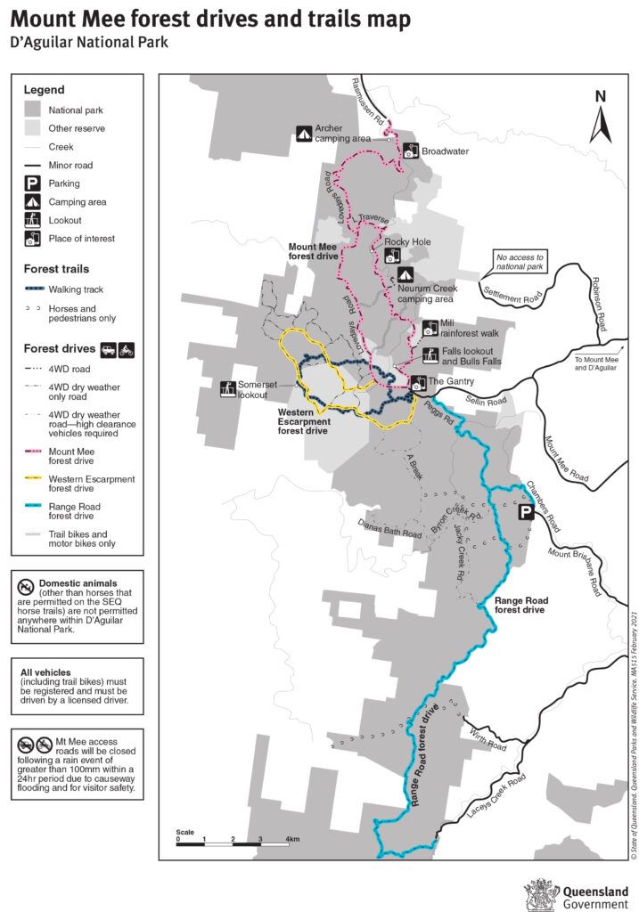
Map showing the forest drives and forest trails through the Mount Mee section of D’Aguilar National Park. Legend provided.
Mount Mee National Park Map – Map from Queensland’s Department of National Parks, Sports and Racing
D’Aguilar National Park map:
Click here to view a map of D’Aguilar National Park and helpful information about camping and activities, including picturesque walks.
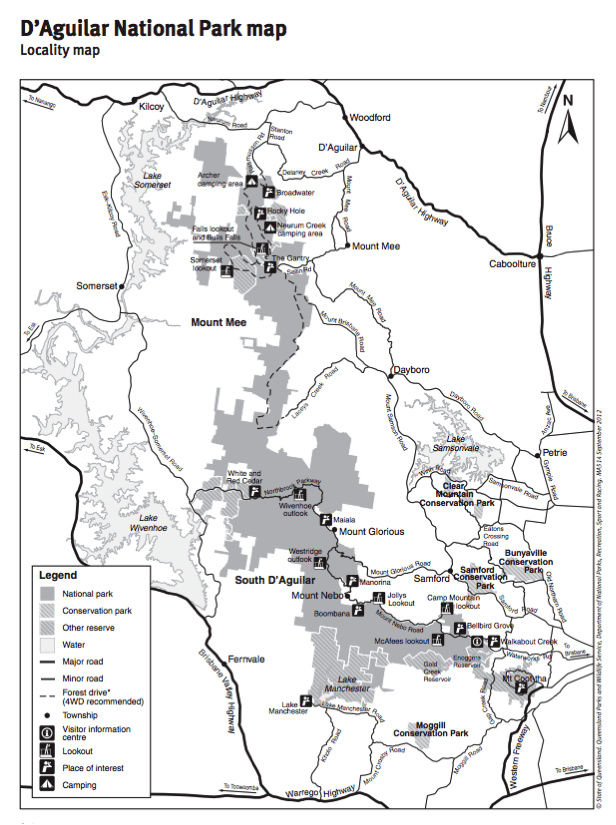
D’Aguilar National Park Map – Map from Queensland’s Department of National Parks, Sports and Racing
4WD Tracks:
Mount Mee offers a range of 4WD tracks that cater to different skill levels. 4WD vehicles are allowed on Mount Mee’s forest drives, unless otherwise stated, and vehicle permits are not required.
Distance: 14km
Drive through gum forest and take in the breathtaking views of Somerset lookout, with views over lake Somerset and Wivenhoe.
Distance: 16km
This drive starts at The Gantry. Head north west through native and plantation forest, to Bulls Falls and Falls lookout. Continue to Mill rainforest walk, head to Rocky Hole and drive to Broadwater, which offers a beautiful spot for a picnic. Drive north to Woodford or return to The Gantry.
Distance: 27km
From The Gantry, travel south east along Peggs Road to Range Road forest drive. Enjoy scenic rainforest and eucalypt forest, stopping at Kluvers lookout for incredible views. Exit the national park at Laceys Creek Road, or continue to Dayboro.
The Mount Mee section of the park has two camping grounds, Archer and Neurum Creek. You’ll find tracks that suit all 4WD driving skill sets, picturesque camping spots and some of the most stunning sites in South East Queensland. These sites are close to Lake Somerset, Kilcoy and Woodford.
D’Aguilar National Park has two main camping areas in Mount Mee section, Neurum Creek and Archer.
Located on the eastern side of Mount Mee national park, this camping spot is nestled in eucalypt woodlands and a short walk to Neurum Creek, which is south of the campsite. Enjoy a swim in the waterhole, during the warmer months. Take in the beautiful views and go hiking through the forest.
How to get there: Take the turnoff at Neurum Creek Road, approximately 6.3km from the southern entrance to the park – Sellin Road via The Gantry. Neurum Creek Road is approximately 13km from the northern, Woodford, entrance to the park.
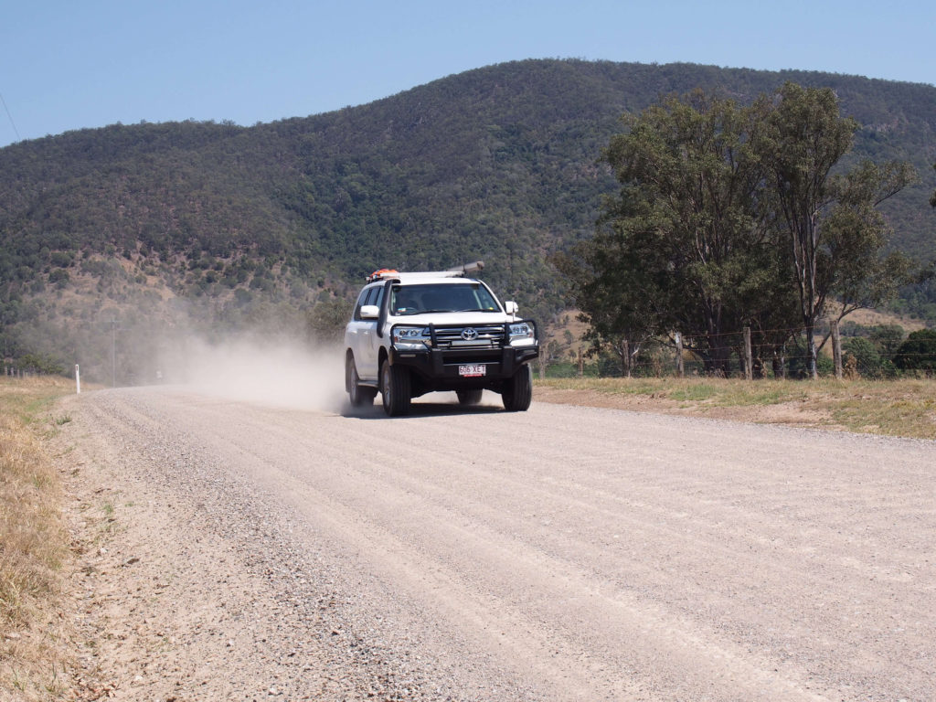
Toyota LandCruiser 200 series does dirt well at Neurum Creek
Number of sites: 13 sites, maximum six people per site.
Camp sites are suitable for: tent camping beside your car and walk-in camping.
Map: Click here to view a map of Neurum Creek camping area.
Cost: (As of May 2024) camping fees are from $7.25 per person or $29.00 per family per night. Click here for more information about camping fees. Book your camping permit here.
Facilities:
As Neurum Creek is a bush camp, no shower facilities or drinking water is provided. Bring sufficient drinking water, as the closest locations to collect water is Woodford or Dayboro.
What to bring:
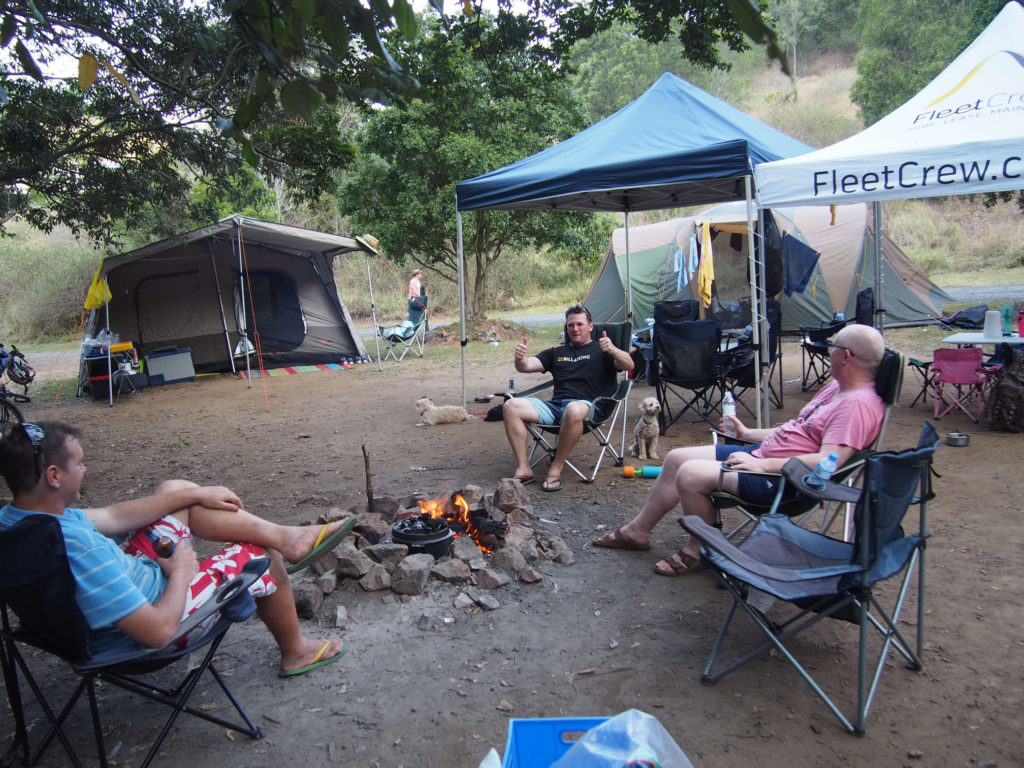
Fleetcrew boys cooking a roast on the camp fire at Neurum Creek
Archer camping area has a beautiful natural bush setting and is located next to Neurum Creek. It is an open camping area that is family-friendly, grassed and shaded by big gum trees.
Things to do:
Water activities
Swim and kayak in Neurum Creek or swim in Rocky Hole.
Bush Walking
Falls Lookout is an easy bush walk that offers a great view of Mount Mee and Neurum Valley.
How to get there: Take the turnoff at Lovedays Road, approximately one kilometre from the northern, Woodford entrance. You will need a 4WD vehicle if you are accessing the campsite from the south, via The Gantry.
Number of sites: 9 numbered camp sites, maximum of 6 people per site.
Suitable for: Tent camping beside your car and walk in camping.
Facilities:
What to bring:
4WD Skill level: Easy
Distance from Brisbane: 300km north
Cooloola Recreation Area is a beautiful spot with sand cliffs, coloured sands and tranquil waterways. Hike through pristine rainforest, swim in the freshwater lakes or camp along the beach.
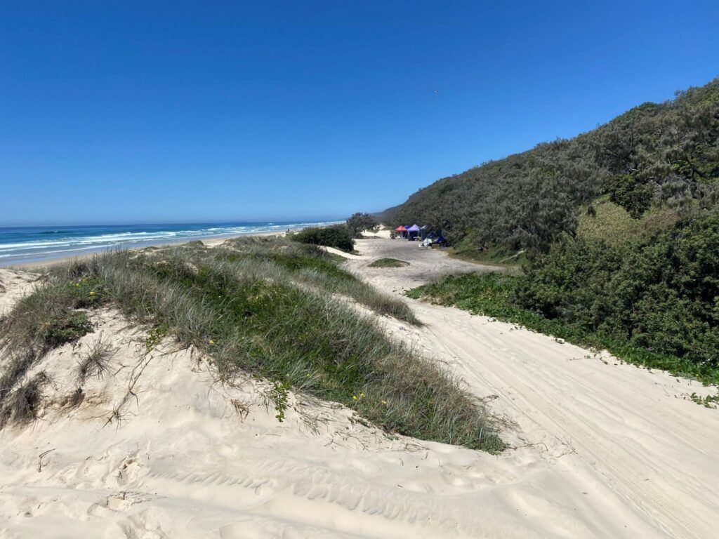
Teewah beach is a stunning spot for beach camping, just north of Noosa.
Features: Teewah Beach camping area offers beach camping without formally defined sites.
Location: Along Teewah Beach in a 15km zone between the Sunshine Coast Regional Council boundary and Little Freshwater Creek; 20km north of 3rd cutting on the Noosa North Shore.
What to bring:
Water obtained from pools or creeks at Teewah Beach is not suitable for drinking, showering or cooking. Treat water before drinking.
Facilities:
No facilities are provided
What to bring:
The freshwater camping area features sheltered sites, with plenty of shade, that are dotted among gum woodland and close to the beach.
Activities:
Suitable for: Tent camping beside your vehicle or walk-in camping
Find out more that you can do around Great Sandy National Park and Cooloola National Park. Make a week of adventure of it. Visit Rainbow Beach, K’gari (Fraser Island), Great Beach Drive, Coloured Sands and Great Sandy National Park.
Book your camping site online here.
4WD Skill level: Easy to difficult
Located 85km southwest of Brisbane, in the Scenic Rim region, Main Range National Park is part of the World Heritage-listed Gondwana Rainforests of Australia. This untouched wilderness is one of the less known parks and has extensive subtropical rainforest.
The main camping areas in Main Range National Park are Spicers Gap, Poplar Flat and Manna Gum at Goomburra. Private campgrounds are available at Queen Mary Falls and Goomburra.
Poplar Flat is an open, grassy area that is close to Dalrymple Creek and in close distance to walking tracks.
Facilities:
What to bring:
Suitable for: Tent camping beside your vehicle or walk-in camping
Manna Gum is an open, grassy area that is close to Dalrymple Creek. Set amongst the manna gums, there is ample shade during the hotter months.
Facilities:
What to bring:
Suitable for: Tent camping beside your vehicle or walk-in camping
This is a small, grassy camping spot on the eastern side of Spicers Gap. Open eucalypt forests, stunning hiking tracks and close to Queen Mary Falls, Spicers Gap is the perfect place for a weekend getaway.
Facilities:
What to bring:
4WD Skill level: Easy to difficult
Only 150km north-west of Brisbane, Benarkin State Forest has one of the best off-road tracks in this region. A scenic forest drive leads through rainforests, hoop pine plantations, eucalypt forests and the picturesque Emu Creek. You can camp at Clancys and Emu Creek camping areas.
This grassy campsite gently slopes down to Emu Creek and has an idyllic, natural bush setting.
Suitable for: Tent camping beside your car and walk-in camping.
Facilities:
What to bring:
This large, open grassy campsite is near a waterhole and ideal for family camping.
Facilities:
What to bring:
Suitable for: Camping beside your car and walk-in camping.
Hire a 4WD in Brisbane
Packing for your 4WD Camping Trip:
Check out this blog and get a checklist of everything you need for your camping trip.
Need to hire a 4WD in Brisbane for your camping trip? FleetCrew has a range of the latest Toyota recreational 4WD vehicles which come with unlimited kilometres, tow bar and luxury interior. Plan and enjoy some of South East Queensland’s best camping spots!
With FleetCrew, you get unlimited freedom as we allow hire vehicles to be driven on the beach. Browse our range of 4WD hire vehicles now or contact us for any enquiries.
If you have an enquiry or would like more information then please fill in the enquiry form and we will get back to you asap during business hours.
If you are seeking a quote for a particular vehicle/s, please visit our Get A Quote page or if want to further information, please visit our FAQs page.
Providing 4WD Hire Vehicles in QLD and the Eastern States
Monday – Friday: 7.30am – 5.00pm