[Updated 14 March 2024]
Right on Brisbane’s doorstep is a tropical island with miles of sandy beaches, spectacular national parks and crystal-clear lagoons. Discover the unspoilt natural beauty of Moreton Island, one of the world’s largest sand islands. Visit the island for a day, a weekend, or spend a relaxed beach holiday at one of South East Queensland’s hidden gems. What better way to enjoy Moreton Island than heading off on a camping adventure? In this article, you’ll find out everything you need to know about 4WD Camping on Moreton Island. Find the best places to camp – from secluded beach camp spots to well-established campgrounds. You will also find out how to get there and the ins and outs about 4×4 driving on the island.
Find out what camping adventures this 4WD island has to offer you.
1. A little more about Moreton Island
2. Camping on Moreton Island
2.1 National Park campgrounds
2.2 North Point camping
2.3 Comboyuro Point camping
2.4 Ben-Ewa camping
2.5 The Wrecks camping
2.6 Blue Lagoon camping
2.7 Beach and Bush camping
2.8 North West Campsite
2.9 North East Campsite
2.10 South West Campsite
2.11 South East Campsite
2.12 Yellow Patch Campsite
3. Packing for your 4WD camping trip
4. What to do during your trip
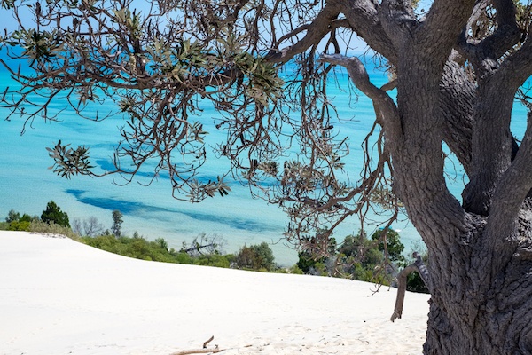
Moreton Island is one of the world’s largest sand islands and has a National Park that covers approximately 98% of the entire Island. There is so much to see at Moreton Island including visiting Queensland’s first lighthouse, snorkeling, and scuba diving around The Wrecks, or tobogganing (sand boarding) down sand dunes.
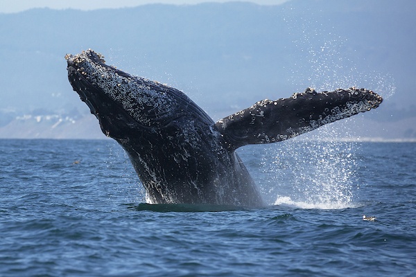
See humpback whales during whale migration season (between July to November) or get a glimpse of turtles, dugongs and dolphins in the bay and surrounding waters. You could also climb the southern hemisphere’s tallest vegetated sand dunes, which is towering 280 metres above sea level.
If you are open to learn a bit about history, you could explore the World War II military ruins of Rous Battery. Swimming in the serene freshwater oasis of Blue Lagoon, or chill out on a white sandy beach are nice alternatives for a more pampered experience! All in all, there’s heaps to do on this beautiful island. Tip: Read our blog post “Top 10 Things to Do on Moreton Island” for our pick of activities on this marvellous island.

Moreton Island is approximately 40 km offshore from Brisbane. You can get to the island by ferry, barge or by boat. Both barges and ferries for vehicles and passengers run daily.
It’s easiest to book your ferry with Moreton Island Adventures. The MICAT ferry departs from 14 Howard Smith Drive, Port of Brisbane and arrives at The Wrecks, Moreton Island. You can get Google Maps directions here. The trip takes approximately 1.5 hours.
Prices:
[March 2024]
You can grab a bite to eat, sip on a freshly brewed cup of coffee or relax on the observation deck and take in the beautiful 360 degrees views of the bay. If you are lucky, you may see whales, dugongs and dolphins in the water.
It’s recommended to check the ferry times, as the ferry only departs once a day during off-peak times. In peak times, it is advisable that you book early, so you don’t miss out.
Moreton Island is an off-roader haven. With no sealed roads, Moreton Island is only accessible by 4WD vehicle. You can drive on the beach, and there are many tracks available, that cater to all 4WD driving skill levels. Our guide to safe beach driving shows you how to drive on soft sand and what to do to ensure that you don’t get stuck.
You will need a 4WD permit to drive on Moreton Island. You can book a Vehicle Access here.
Moreton Island map:
This Moreton Island map shows the major 4WD tracks, campgrounds and attractions, including Cape Moreton and The Wrecks.

Map credit: Queensland Department of National Parks, Sports and Racing.
If you are interested in finding out more about four-wheel driving on Moreton Island you can hit our dedicated 4×4 driving post here.
There are many camping experiences available on Moreton Island. Most are accessible by 4WD, while others are accessible by boat or close to the ferry landing points.
You can choose to camp in the five main campgrounds, with facilities that include toilets and cold showers, or stay in the camping zones along the beach or bush, which have no facilities.
To stay in Moreton Island National Park, you will need to book a camping permit, and your camping tag with your booking number must be displayed at your campsite at all times. Camping permits must be bought before you arrive on the island as there is no self-registration on sites.
Pricing fees (pricing current as at March 2024):
Visit the Queensland Department of National Parks to book your Queensland National Parks camping permit.
Camping zones map:

Map credit: Queensland Department of National Parks, Sports and Racing.
What should you consider to bring:
Firewood:
Bring your own untreated firewood as collecting firewood is not allowed on the island. You can purchase firewood from the Bulwer General Store, near the ferry departure point. Please be aware that fire bans may apply.
Gas and fuel stoves
A gas or fuel stove means that you can cook even in poor weather, but be aware that you cannot light any fire during a fire ban period. You can check what’s allowed on Queensland Fire and Emergency Service’s page here.
Portable toilets
The five larger campsites have toilets, while beach and bush camping sites will not have toilet facilities. Waste from portable toilets can be emptied at the designated waste facilities at Comboyuro and Ben-Ewa camping areas.
Drinking water
Boil or treat all water collected on the island before drinking. Water is available at:
Campsite features: North Point has a large grassy camping area with some shady sites, close to the surf beach. It’s within walking distance of Honeymoon Bay and Champagne Pools.
Location: The campsite is located on the northern tip of the island between Yellow Patch and Cape Moreton.
Number of sites: A maximum of 17 sites are available.
Facilities:
What to bring: Drinking water, water sterilisation tablets, rubbish bags, sealable containers for rubbish, sand pegs, insect repellent, first aid kit.
What to do in this area:
Campsite features: Large camping area with shady campsites. This campsite offers sheltered bay waters for swimming.
Location: Comboyuro Point is within walking distance of Bulwer township, which is on the west coast of the island. This campsite is close to the central 4WD tracks that will take you to some of the best island destinations.
Number of sites: This site has 49 camping plots marked with totems.
Facilities:
What to bring: Drinking water, water sterilisation tablets, rubbish bags, sealable containers for rubbish, sand pegs, insect repellent, first aid kit.
What to do in this area:
Campground features: Ben-Ewa is set in a valley, which provides protection against strong winds and has shady trees. These medium sized, shady sites are a favourite with families as it is close to the sheltered bay waters.
Number of sites: 12 camping sites available.
Location: The site is located on the western beach side of the island, and 1.5 km north of The Wrecks.
Facilities:
What to bring: Drinking water, water sterilisation tablets, rubbish bags, sealable containers for rubbish, sand pegs, insect repellent, first aid kit.
What to do in this area:
Campground features: Medium–sized, defined sites set next to a sheltered bay. Sites are well defined and surrounded by native trees and shrubs.
Number of sites: A maximum of 21 sites are available.
Location: The Wrecks is a walk-in camping close to the main barge landing point for Moreton Island Ferries. The campground is suitable for walkers, boaties and campers without vehicles.
What to bring: Drinking water, water sterilisation tablets, rubbish bags, sealable containers for rubbish, sand pegs, insect repellent, first aid kit.
What to do in this area:
A QldParks-Wifi hotspot is available at The Wrecks camping area to help you book, extend your camping, check park information and access other related websites.
Campground features: With beautiful walking trails to the nearby lake and close proximity to the surf beach, this camping area is set in an idyllic spot.
Location: On the eastern side of the island between Middle Road and Cape Moreton.
Number of sites: A maximum of 25 sites are available.
What to bring: Drinking water, water sterilisation tablets, rubbish bags, sealable containers for rubbish, sand pegs, insect repellent, first aid kit.
What to do in this area:
For a rugged adventure choose a beach camping zone. The five beach camping zones on Moreton Island are north-west, north-east, south-west, south-east and Yellow Patch. There are no facilities in these camping zones. It is essential to bring all necessities including drinking water.
Camping zone features: This camping zone offers calm bay waters, and many sites have water views and shade.
Location: This camping area is located on the western beach between Ben-Ewa and Comboyuro Point campgrounds.
Number of sites: A maximum of 76 sites are available.
Facilities:
Camping zone features: Many sites have water views and shade, with secluded sites.
Location: Covers all eastern beach campsites between Middle Road to Spitfire Creek on the Eastern surf beach.
Number of sites: A maximum of 89 sites are available.
Facilities:
Camping zone features: This camping zone offers calm bay waters, and many sites have sea views and shade.
Location: Covers all western beach campsites from Tangalooma Bypass to Toulkerrie. Some campsites that are close to Toulkerrie may only be accessible by 4WD at low tide.
Number of sites: A maximum of 24 sites are available.
Facilities:
Camping zone features: Many sites have ocean views and shade. Kooringal is the closest township. This camping zone has exposed surf beaches.
Location: Covers all eastern beach campsites between Middle Road to Rous Battery on the eastern surf beach side.
Number of sites: A maximum of 35 sites are available.
Facilities:
Camping zone features: Many sites have sea views and shade. This camping zone offers surf beaches, but it’s not as exposed as the surfside. North Point campground is a short drive, which has toilets and a cold water shower.
Location: Covers all western beach campsites in the Yellow Patch area, between North Point and Heath Island.
Number of sites: A maximum of 14 sites are available.
Facilities:
Camping essentials:
The essentials that you need to take on your camping trip to Moreton Island include:
4WD camping equipment checklist:
Click here to view our 4×4 camping equipment checklist, which shows you what you need to take on a 4WD camping trip.
Scenic drives on Moreton Island
To fully discover Moreton Island, try these two drives:
Southern Island Discovery
Distance: 63km circuit
Drive time: 6 hours
Access Point: Tangalooma Wrecks beachfront or any point south of Middle Road along the eastern or western beaches.
Northern Island Discovery Drive:
Distance: 55km circuit
Drive time: 6 hours
Access point: Tangalooma Wrecks beachfront or any point north of Middle Road along the eastern or western beaches.
Walks on Moreton Island
Blue Lagoon track:
Distance: 500m return and walk time 20 minutes.
Access point: Ocean Beach, north of Bulwer-Blue Lagoon Road.
Honeyeater Lake track:
Distance: 60m return and walk time 5 minutes.
Access point: Northern end of North Point camping spot.
Cape Moreton track:
Distance: 1.5km circuit and walk time 1 hour.
Access point: Cape Moreton car park.
Telegraph Road track:
Distance: 16km return and walk time 6 hours.
Access point: Mount Tempest car park off Middle Road.
Five Hills lookout track:
Distance: 1km return and walk time 30 minutes.
Access point: Five Hills, off Bulwer-North Point Road.
Rous Battery track:
Distance: 9.8km one way and walk time 3.5 hours.
Access point: The Desert Road.
Mount Tempest lookout track:
Distance: 2.2km return and walk time 2 hours.
Access point: Mount Tempest car park off Middle Road.
Read our previous article to find out the top attractions on Moreton Island. Some of the most popular things to do include:
Need a 4WD vehicle for your ultimate Moreton Island trip? Fleetcrew offers you a range of the latest Toyota 4WD vehicles – all available for hire. With our South East Queensland hire vehicles, you get unlimited kilometres and can drive on the beach. Discover the world’s largest sand islands including Moreton Island, K’gari (Fraser Island) and Straddie with Fleetcrew.
Check our recreational 4WD vehicles here and start planing your awesome trip!
If you have an enquiry or would like more information then please fill in the enquiry form and we will get back to you asap during business hours.
If you are seeking a quote for a particular vehicle/s, please visit our Get A Quote page or if want to further information, please visit our FAQs page.
Providing 4WD Hire Vehicles in QLD and the Eastern States
Monday – Friday: 7.30am – 5.00pm